
Managing Conflicting Land Use Interests: A Practical Guide

The most effective way to manage conflicting land use interests is to combine three linked levers: interest-based mediation, spatial multi-sector scenario planning, and targeted policy instruments. Used together, this integrated approach outperforms any single tool applied alone. A Lincoln Institute study evaluating nearly 300 land use cases found that mediation screening and facilitated negotiation reduce court burden, save time and money, and limit community polarization. Recent multi-objective planning research shows balanced scenarios can retain nearly 90% of a sector-specific objective, such as renewable energy capacity, while still protecting habitats and carbon stocks. The federal Conservation Reserve Program shows how targeted incentives can align private and public interests without forcing a binary win or lose outcome.
Three actions get this moving:
Screen the dispute for mediation suitability before positions harden.
Commission a spatial scenario analysis to map trade-offs across sectors.
Appoint a community liaison who can carry information both directions.
Key Takeaways
Managing conflicting land use interests works best when mediation, spatial scenario planning, and targeted policy tools operate together rather than in isolation.
Point | Details |
Screen before you negotiate | Assess stakeholder count, issue complexity, and permitting stage before committing to mediation. |
Map trade-offs spatially | Commission scenario planning to reveal conflict hotspots and co-location opportunities early. |
Lock in outcomes with policy tools | Match zoning, easements, or subsidies to the specific type of dispute you face. |
Design for durability | Build monitoring triggers and escalation ladders so agreements survive political change. |
Bring in structured support | Amautapublicaffairs sequences mediation support, scenario procurement, and policy drafting for land use and infrastructure clients. |
Table of Contents
How Do You Start Managing Conflicting Land Use Interests in 30 to 90 Days?
Momentum in the first quarter determines whether a dispute stays negotiable or calcifies into litigation. Start with a conflict screening memo within two weeks, then move quickly to assign ownership before positions harden.
Weeks 1 to 4: Complete a conflict screen, draft a short data brief on the site and stakeholders, and appoint a convenor.
Weeks 4 to 8: Begin mediation intake if screening supports it, and issue a scope of work for spatial scenario planning.
Weeks 8 to 12: Launch the first scenario workshop and confirm a communications liaison is active with the community.
Role | Core responsibility |
Convenor | Sets agenda, selects mediator or facilitator, keeps timeline on track |
Community liaison | Manages two-way communication, tracks concerns, reports to convenor |
Regulator | Confirms permitting requirements and legal boundaries for negotiated terms |
Developer | Provides technical data, funds studies, commits to negotiated conditions |
When Should You Use Mediation for Land Use Disputes?
Mediation works best when a dispute has multiple stakeholders, unresolved technical questions, and no court order forcing an outcome yet. It works less well once litigation has already locked parties into fixed legal positions. Screen for three things: how many distinct interest groups are involved, whether the underlying issues are factual (traffic counts, water tables) or purely values-based, and where the project sits in the permitting cycle.
A practical mediation flow looks like this:
Screen the dispute using the criteria above.
Select a mediator with no financial stake in the outcome.
Run confidential caucuses to map each party’s actual interests, not just stated positions.
Generate options that trade across issues rather than splitting the difference on one.
Draft a written agreement tied to conditional approvals.
The Lincoln Institute’s review of nearly 300 cases found improved settlement rates and better participant experience when mediation was used before litigation, not after.
Pro Tip: Vet your mediator or screener for financial and political independence before the first session. A convenor with ties to either side, even a small consulting contract from years back, can undermine trust in the entire process.
What Does Spatial Multi-Sector Planning Reveal About Trade-Offs?
Spatially explicit scenario planning, often called SESP, overlays competing land uses (conservation corridors, energy siting, agriculture, housing) on the same map to show exactly where they collide. This turns an abstract argument about “development versus conservation” into a concrete picture of which specific parcels are contested and why. Researchers describe SESP as both a technical tool and a platform for dialogue, because the maps themselves become the shared reference point for negotiation.
Useful outputs to commission include:
Conflict-hotspot maps showing where competing designations overlap
Trade-off visualizations (Pareto fronts) comparing outcomes across scenarios
Co-location suitability maps identifying where uses can coexist rather than compete
Scoping an SESP contract requires parcel-level land cover data, habitat and carbon inventories, and a technical partner comfortable with multi-objective modeling. Global trade-off analysis confirms that site-specific evaluation matters more than applying broad regional results to a local parcel.
Pro Tip: Design maps for a non-technical audience from the start. A trade-off visualization that only a GIS analyst can read will not move a skeptical stakeholder at a public workshop.
Balanced multi-sector scenarios have achieved nearly 90% of a renewable energy objective while safeguarding habitat and carbon stocks, evidence that trade-offs are rarely as zero-sum as they first appear.

Which Policy Instruments Align Competing Land Use Interests?
Mediation and scenario maps identify what a durable deal could look like. Policy instruments lock it in. The right tool depends on the type of conflict.
Conditional zoning ties approval to specific, negotiated performance standards.
Conservation easements permanently restrict development on sensitive parcels in exchange for compensation.
Density bonuses let developers build more in exchange for public benefits elsewhere on site.
Mitigation banks offset unavoidable habitat loss with restoration credits purchased elsewhere.
Targeted subsidies, such as an environmental benefit index, direct funding toward the highest-value conservation outcomes rather than spreading it flat.
The Conservation Reserve Program’s environmental benefit index is a working U.S. example: it ranks projects by ecological uplift rather than funding applicants on a first-come basis, which concentrates public dollars where they do the most good. Habitat-versus-development disputes tend to favor easements and mitigation banks; renewable siting conflicts with farmland often respond better to conditional zoning paired with density bonuses. Expect legal drafting and enforcement design to take longer than the underlying policy analysis itself.
How Do You Build Trust With Stakeholders During a Land Use Conflict?
A community liaison needs clearly bounded authority: enough to answer questions and relay concerns accurately, but not so much that residents mistake them for the final decision-maker. That distinction has to be communicated up front, or the liaison becomes a target for frustration that belongs elsewhere.
Effective outreach mixes formats rather than relying on one big public hearing. Small-group listening sessions surface concerns that people won’t raise in a crowded auditorium. Scenario workshops built around the spatial maps discussed above let residents see trade-offs directly instead of hearing them summarized secondhand. Targeted outreach to specific interest groups, farmers, tribal nations, environmental groups, small businesses, respects that each has different stakes and different vocabulary for describing them.
Share data transparently, including the assumptions behind any model or projection.
Use maps and trade-off visuals instead of narrative descriptions when explaining compromises.
Frame criteria as jointly developed, even when your team drafted the first version.
Avoid rights-based language (“we have the right to build here”) when the goal is an integrative deal, since it signals a fixed position rather than an interest to negotiate.
Pro Tip: Publish the same trade-off maps you use internally. Stakeholders trust a process more when they can see the same information the project team is working from, not a simplified summary.
Guidance on structuring these conversations appears in this stakeholder communication playbook, and a companion trust-building framework covers tactics for new development specifically.
How Do You Keep Land Use Agreements From Falling Apart?
Agreements that survive a change in city council or a new developer on the project share one trait: they rely on interests, not just rights. The Lincoln Institute’s research on land use disputes notes that rights-based systems tend to adjudicate winners and losers, while interest-based agreements hold up better because they reconcile what each party actually needs.
Structure escalation so litigation is the last resort, not the default:
Negotiated agreement with jointly defined terms
Conditional approval paired with ongoing monitoring
Administrative review if a party disputes compliance
Binding arbitration before litigation is ever filed
Track compliance against baseline, target, and trigger levels for legal, environmental, and social metrics.
Attach easements, covenants, or permit-linked contract clauses to make key terms enforceable regardless of who holds office next.
What Does an Implementation Timeline Look Like?
Budget planning matters as much as sequencing. Technical studies, facilitator fees, subsidy or incentive funding, and legal drafting are the four line items that most often get underestimated.
Phase | Window | Key milestone |
Screening and setup | 0 to 4 months | Convenor appointed, mediation screen complete |
Negotiation and planning | 3 to 8 weeks | Scenario planning complete, negotiated agreement drafted |
Approval and monitoring launch | 8 to 12 weeks | Conditional approvals issued, monitoring protocol active |
The convenor typically leads screening and mediator selection.
The developer usually funds technical studies and incentive costs.
The regulator confirms compliance milestones and reporting cadence.
Balanced multi-sector scenarios that retain close to 90% of a sector objective tend to move through approval faster, because fewer parties feel they lost outright.
How Do You Monitor Land Use Agreements Over Time?
An agreement is only as durable as the data behind it. Track a habitat condition index, the gap between permitted and actual buildout, a complaint-and-resolution rate, and periodic social acceptance surveys. Set adaptive triggers in advance: if buildout diverges from the permitted plan by a defined margin, or if habitat metrics fall below a threshold, that triggers renegotiation rather than a slow drift into noncompliance.
Remote sensing data for land cover and habitat change over time.
Permit databases to compare approved versus actual construction.
Community surveys to catch social friction before it becomes formal complaint.
Third-party audits to verify compliance without relying solely on self-reporting.
Pro Tip: Set your renegotiation triggers before the agreement is signed, not after a dispute arises. Parties agree more easily on thresholds when nobody yet knows which side they’ll benefit.
How Does AMAUTA Apply This Integrated Approach in Practice?
Amautapublicaffairs sequences these three levers as a matter of standard practice rather than treating them as separate services. A project typically starts with a stakeholder landscape assessment, moves into facilitated engagement and mediation support where a dispute is screened as suitable, and runs in parallel with scenario planning procurement when spatial trade-offs are the central issue.
On these engagements, Amautapublicaffairs commonly serves as convenor, communications lead, or permit liaison, sometimes all three depending on project scope. Land management work spans conservation, energy, and infrastructure projects where competing interests need a structured path to agreement, not just a public comment period. [Client case studies and effectiveness metrics] will be added here as engagements are documented.
How Can AMAUTA Help You Manage a Land Use Conflict?
If your project is stuck between a developer’s timeline, a regulator’s checklist, and a community that feels unheard, the gap usually isn’t lack of goodwill. It’s lack of structure. Amautapublicaffairs builds that structure directly: stakeholder mapping, mediation facilitation support, spatial scenario procurement, and policy drafting, sequenced the way this guide describes rather than bolted together after a dispute has already gone public.
A short readiness assessment can tell you which lever (mediation, scenario planning, or policy design) matters most for your specific conflict before you commit budget to any of them. That assessment starts with a conversation, not a proposal. Review the full range of public affairs and community engagement services Amautapublicaffairs provides for land use, energy, and infrastructure projects, then get connected to scope your next step.
Frequently Asked Questions
What is the fastest way to manage conflicting land use interests? Screen the dispute for mediation suitability within the first two to four weeks. Early screening, before positions harden, is what let the cases in the Lincoln Institute’s nearly 300-case study settle faster than those that went straight to litigation.
Does mediation work for every land use dispute? No. Mediation works best when multiple stakeholders are involved and the dispute hasn’t yet been locked into a formal legal posture. Once litigation is filed, options narrow significantly.
What is spatial multi-sector planning used for? It maps competing land uses, conservation, energy, agriculture, and housing, on the same set of parcels to show exactly where interests collide and where co-location is possible, turning abstract disagreement into a visible trade-off.
How do local governments pay for scenario planning and mediation? Costs typically come from a mix of developer-funded technical studies, municipal planning budgets, and in some cases targeted federal or state incentive programs like the Conservation Reserve Program’s environmental benefit index.
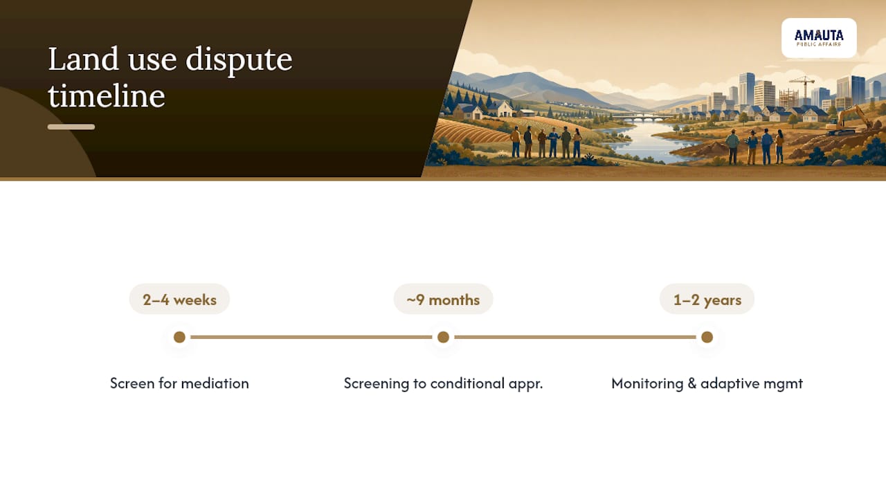
How long does it take to reach a durable land use agreement? Most structured processes run from screening through conditional approval in roughly nine months, with monitoring and adaptive management continuing for one to two years afterward to confirm the agreement holds.
Sources
Recommended
Comments